WAVE Smartphone Application Brings Variety of Information to Commercial Fishermen
![]() A new, free smartphone application is now available to improve emergency preparedness for those who navigate Louisiana waters. Waterway Information for Vessels, known as “WAVE,” went online in November. It is unique because it brings a host of useful data from numerous sources into a single mobile platform.
A new, free smartphone application is now available to improve emergency preparedness for those who navigate Louisiana waters. Waterway Information for Vessels, known as “WAVE,” went online in November. It is unique because it brings a host of useful data from numerous sources into a single mobile platform.
Lauren Land, Louisiana Sea Grant’s (LSG) sustainability coordinator, served as project manager for the multi-disciplinary team from four different entities at Louisiana State University that created the app. The idea grew from Sea Grant’s work on harbors of refuge, with the initial goal of helping commercial fishermen locate safe mooring for their vessels in the event of a major storm.
“If fishermen are away from their home port, they don’t necessarily know where to go when a hurricane approaches,” she explained. “However, we learned that if a captain is not in the habit of opening an application, then it will not be used in an emergency. We started talking with fishermen and interviewing them to learn what information they would want year round. We decided to integrate a variety of helpful data that boaters can use every day.”
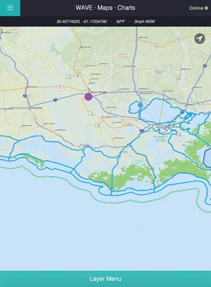
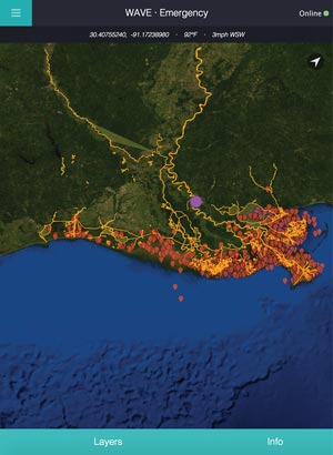 Land facilitated conversations among the project team, commercial fishermen, LSG Marine Extension agents, and local and state agencies to further the app’s operational capabilities. As a result, WAVE users can toggle on and off the layers of information they want to view, including maps; charts; weather conditions, warnings and forecasts; fisheries data; and historic storm information. The application also shows publicly owned waterfront areas, and an emergency preparedness section is provided for Vermilion Parish.
Fisheries content is drawn from the Louisiana Department of Wildlife and Fisheries and includes public seed grounds, private oyster leases, boundaries for fresh- and saltwater shrimp zones, and Louisiana Department of Health and Hospitals harvesting areas and how they are classified. National Oceanic and Atmospheric Administration content includes electronic navigation charts and raster navigational charts, the latter of which is similar to what a captain might print and store on the boat. The charts are built into the application and can be accessed in the absence of an Internet connection, which can be a limiting factor when boats travel offshore. The application also incorporates data compiled from the Coastal Emergency Risks Assessment (CERA) model. For example, uses can select a monitoring station and see one line for observed storm surge and another for predicted storm surge in a particular area. For comparison’s sake in a storm situation, boaters can also access databases of prior hurricanes to view historical high water marks, storm surge, hourly position and intensity. For weather and tide information, the app will continuously update while it has online access and will show the time of the most recent update when the smartphone does not have an active Internet connection. The design is adaptable and scalable and can be adjusted to incorporate other types of data.
 WAVE was made possible with funding from the LSU Coastal Sustainability Studio’s 2014-2015 Small Projects Fund. Other WAVE team members include lead application developer Danny Holmes, a Ph.D. candidate at LSU’s School of Music and an employee at LSU’s Center for Computation and Technology; Carola Kaiser, an information technology consultant and GIS specialist with LSU’s Coastal Sustainability Studio; Hal Needham, program manager for NOAA’s Southern Climate Impacts Planning Program at LSU; Marc Aubanel, director of Digital Media Arts and Engineering at LSU’s Center for Computation and Technology; and Alexa Andrews, project manager with the Center for Business Preparedness at the Stephenson Disaster Management Institute at LSU.
WAVE was designed for iPhone and iPad and is available as a free download through the Apple App Store at https://itunes.apple.com/us/app/wave-waterway-information/id1056713560?mt=8.
On the Web:
WAVE, http://wave.laseagrant.org
LSU Coastal Sustainability Studio, http://css.lsu.edu/